Introduction
In September 2023 Angela and I joined a group of friends, 16 of us in all, for a fabulous time of cycling and hiking in Utah, staying in Moab. The trip was organized by our cycling comrades Lori and Wayne. They’ve led a half-dozen trips to Moab, and put enormous effort into finding the best options for hiking and cycling in the region, and ensuring everyone on the trip has the best experience possible.
This page is a placeholder for our photos from the trip, as well as information about each hike or bike ride. Each activity includes:
- a photo album on its own page
- each ride has a link to the route, in RideWithGPS
- each ride also has an animated playback on a 3D map, using Relive
Like most folks on the trip, we drove out to Moab from Ottawa, finding our own way. We drove two long days to South Dakota and then slowed down to spend some time in the Badlands and Black Hills of South Dakota.
Driving to Moab
We took the Trans Canada Highway northwest from Ottawa and crossed into the US at Sault Ste. Marie, and stopped at Escanaba, Michigan for the night. The next day was a long drive down the west coast of Lake Michigan, then west through the endless farmlands of Wisconsin. We skirted Minneapolis before getting on the I90 for South Dakota. The scenery turned to rolling grassland prairie, interrupted by countless billboards along the interstate advertising all manner of tourist attractions. Judging by the number of billboards, the Wall Drug Store in Wall, SD was a must-visit for any self-respecting tourist to the area. We stopped for the night in Oacoma, and had dinner at Al’s Oasis, which was worth the visit to get the South Dakota tourist experience!
Badlands, South Dakota, Sept 21
We started with a stop at Minuteman Missile National Historic Site on the I90 and visited the museum, but didn’t manage to actually fit a visit to one of the missile silo sites into our day. We took SD-240 south from Minuteman Museum, got our US National Parks Pass at the Badlands NP entrance, and then stopped at the Big Badlands Overlook for our first view of the Badlands. We then hiked the Door, Castle, and Notch Trails before heading to the Ben Reifel Visitor Centre, where we ate our lunch (There’s no food in the park, you need to bring your own). The Notch trail, with its log rope ladder, and rugged scenery was particularly great.
After lunch, we continued down SD-240 and stopped at Saddle Pass Trailhead, where we took the trail from the valley floor up to the mesa., and did a short hike on the flat open mesa before heading back. We made a few stops at the many scenic overlooks, but no more hiking.
We visited two prairie dog towns, with hundreds of prairie dogs in each one. They are extremely cute and great fun to watch from the side of the road. Roberts Prairie Dog Town, the largest, is down Rim Road, a washboard dirt road on open prairie where we also saw buffalo and pronghorn.
We turned north on Sage Creek Road and traveled North, rejoining SD-240 just before it crossed the I90 to Wall, SD. The town’s main street is a huge tourist attraction, with the Wall Drug Store taking up a whole block. After a brief tour of the store and a stop at the restaurant for their 5-cent coffees, we jumped back on the I90 and headed to Rapid City, where we spent the night.
(Foggy) Mount Rushmore, South Dakota, Sept 22nd
We drove south on US-16 out of Rapid City, through the tourist town of Keystone, to arrive at Mount Rushmore A tourist attraction done in the patriotic American style. It was a dreary day with drizzle, fog, and low clouds, so the monument was not visible. We walked the Presidential Trail Loop, which took us right to the base of the sculptures, where we were close enough to make them out through the fog.
While there’s lots to see in the Black Hills around Mt Rushmore, we had a long drive ahead of us. We only stopped at Jewel Cave. There were no cave tours available (you need to book days in advance), so we just toured the visitor center. We crossed into Wyoming on US-16 and then headed south on US-85 the “CanAm Highway”. Hours of driving through rolling, open short-grass prairie with very little signs of civilization. We spent the night in Cheyenne, WY a transportation center at the intersection of two busy interstates, and a major east/west rail line.
Across the Continental Divide, Sept 23
We started our final driving day late, as high winds gusting to 100kph made driving risky. When we finally did head south on the I25, we saw several trailers overturned by the winds, and many more prudent truck drivers parked waiting for the wind to die down.
We turned west after Fort Collins and drove up to the scenic Rockies on US-34 through Big Thompson Canyon to Estes Park and Rocky Mountain National Park. We planned to drive through the park, but at the visitor center discovered that like many of the popular US national parks, there was a timed entry permit system, and the permits for the day were sold out.
So we drove south down CO-7, which was very scenic but slow with the hills and twisty road, and through the casino town of Central City Then onto the I70 where we headed west across the continental divide through stunning vistas, to our destination at Fruita Colorado.
Cycling and Hiking
Colorado National Monument Bike Ride, Sept 24th
While officially not part of the Moab trip, half the group met a Fruita to ride a loop around the Colorado National Monument. A great ride with a long, but shallow climb of 600m over 20km, followed by an equally long descent. The route followed the edge of the mesa, with spectacular views on a sunny day.
Following the ride, we did the two-hour drive west along the I70, into Utah then south on UT-128 through remote, open range to meet the Colorado River, and followed the river canyon to Moab Utah. We all stayed at the Sun Outdoors Arches Gateway, near the north end of Moab.
Corona Arch Bike & Hike, Sept 25th
Our first “official day” involved a short 20km ride along the Colorado River to the Corona Arch trailhead, with a stop at the Potash Roadside Petroglyphs. After a change into hiking gear, we hiked to the spectacular Corona Arch.
My Long Canyon Gravel Explore, Sept 25
While the others cycled back to Moab, Bill rode further downriver to Long Canyon Road, a rough 4x4 trail, to do a gravel ride recon, riding his 650b knobby mountain bike wheels. “Rowdy” it was - rough with steep climbs of close to 20%! He made it about halfway up the road before turning back.
- Strava Log (Starting from Corona Arch)
Canyonland Mesa Cycle, Sept 26
Today we drove to Canyonlands National Park, Islands in the Sky sector, and basically rode all the paved roads on the mesa. And stopped at all the lookouts over the Colorado and Green River canyons and gawked in amazement.
Arches Devil's Garden Hike, Sept 27
We got up before sunrise, and before the Arches National Park timed entry permits started, to get to the Devil's Garden trailhead just before the sun came up. We did the challenging and spectacular loop of Landscape Arch, Double O Arch, and Primitive Trail with lots of scrambling and climbing.
Arches National Park Cycle, Sept 28
Today we rode from Moab to Arches National Park, and the full length of the park back to the Devi’s Garden trailhead we drove to yesterday. A wicked headwind on the way back blew us around!
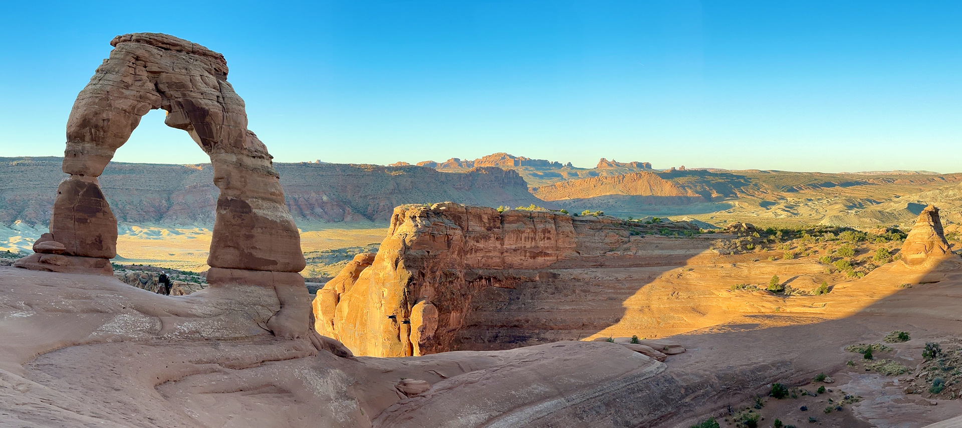
Delicate Arch Sunrise, Windows Arches Sunset Hikes, Sept 29
Another early start to get to the Delicate Arch trailhead before sunrise, for the short hike to the iconic Delicate Arch. This is the arch that defines Utah, depicted on the Utah license plates.
The other activity today was an evening trip to the Windows Arches to watch the sunset. The full moon was rising through the center of the North Window, so the many landscape photographers had arrived early to stake out their positions.
Sand Flats Recreation Area Gravel Explore, Sept 29
Today was a free day, and Bill used the day to explore the gravel and off-road trails on the Sand Flats Recreation Area, above Moab to the east. And was persuaded to ride a few hundred meters of the Slick Rock Mountain Bike Trail practice loop
Canyonlands Murphy Loop Hike, Sept 30
Back to Canyonlands today to hike the Murphy Loop Trail, from the mesa top down the canyon wall to White Rim at the bottom of the Green River Canyon. The 300-meter cliff “looks like sheer rock with no possibility of a safe trail”, but with all the switchbacks the trail is spectacular but very doable.
Fisher Towers Hike, Oct 1
Our last official hike of the trip, Fisher Towers offered spectacular, overwhelming, and bizarre landscapes. And our only rainy day.
Grandstaff Canyon Hike, Oct 2
We were scheduled to ride south of Moab along a quiet road on the open grassland to the Canyonlands Needles Overlook, but there was a fierce wind and most people, including us, decided not to ride. We drove to the Overlook, stopped at The Hole N" The Rock, on the way back, and then hiked the Grandstaff Canyon Trail near Moab.
La Sal Mountain Loop Ride, Oct 3
Our last ride was an epic - up into the La Sal Mountains with one massive climb, some up and down with great views towards Moab, then a massive descent, full of switchbacks. And chilly at 8,000ft.
Little Wild Horse Slot Canyon Hike, Oct 4
Little Wild Horse Canyon was a “bonus hike” at the end of the official trip. Located near Goblin Valley State Park, about 2.5 hours southwest of Moab, the hike consisted of two slot canyons, Bell Canyon being the second.
After the hike, Angela and I drove another 3 hours on UT-24, through Capitol Reef National Park to Bryce Canyon City, just outside Bryce Canyon National Park. Lots of spectacular countryside, and very remote. We stayed at Ruby’s Inn Best Western Plus, A huge sprawling complex filled with international tourists.
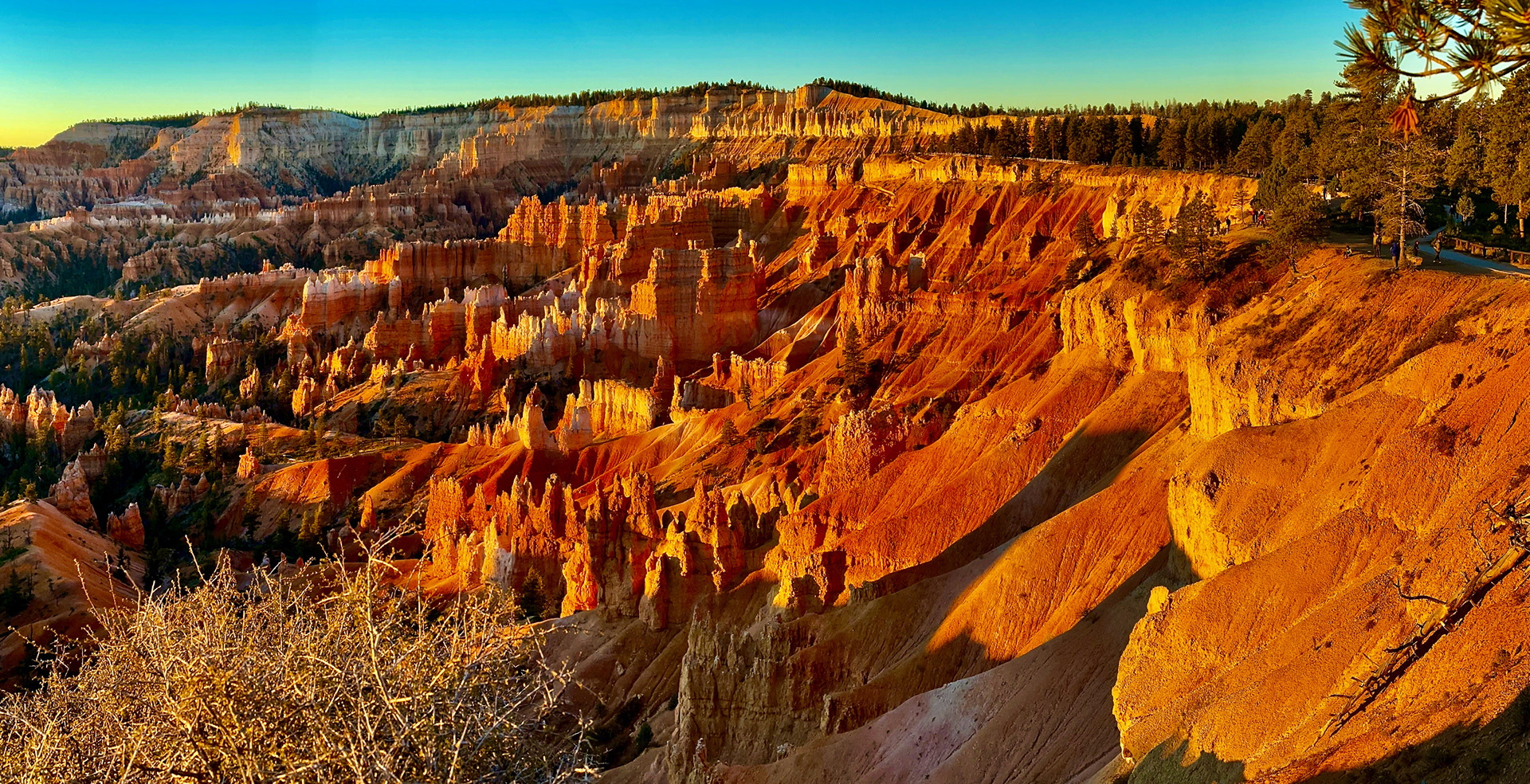
Bryce Canyon Hike & Visit, Oct 5
We spent a full day in the park, rising early so we could get to Sunrise Point in the park before sunrise. It was easy to park, and the crowds were light. After admiring a spectacular sunrise we descended into the canyon, hiking the Navajo Loop and Peekaboo Trails, making a figure 8. By the time we climbed out of the canyon on Queen’s Garden, the trail was clogged with tourists and “tourons”
After lunch we drove the length of the Bryce Canyon Road along the top of the canyon, stopping at every interesting lookout. We did a short hike at Rainbow and Yovimpa viewpoints. By now the roads and parking lots were clogged with traffic and tourists, but we did stop at Bryce Point Overlook with its superlative views of the canyon.
Returning Home
We were keen to get back, so we took a direct route home, driving 10-hour days. We took US-89 north to the I70 and then headed east, the spectacular Utah landscape making the trip very interesting. We even saw a roundup - real cowboys on horseback herding a couple of hundred cattle towards a corral. We took the I70 through the Colorado Rockies, past Denver, and stopped for the night in Fort Morgan, CO.
Then across the US prairies on the I80 - Nebraska, Iowa, Illinois. Around the bottom of Lake Michigan past Chicago, and into Michigan. We crossed at Port Huron/Sarnia and spent the last night on the road in London Ontario. In an area I know very well, near Forest City Velodrome where I've done a lot of riding. And then the familiar drive down the 401 from London home.